Avvikene skyldes oftest manglende eller unøyaktig registrering av bygningspunkt i matrikkelen. Rettes vanligvis i matrikkelen
Kommune | LokalId | Areal (m2) | Posisjon | WMS-bilde |
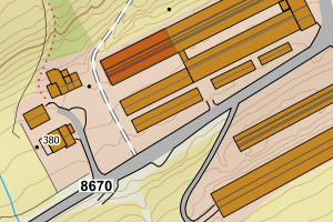
5503 Harstad | f1a73d8f-da8f-4343-9ced-e955839adb60 | 1183.14 | N: 7631881.04, Ø: 561989.64 | ![Kartbilde fra WMS-tjeneste av avviket](https://wms.geonorge.no/skwms1/wms.topo?VERSION=1.1.1&SERVICE=WMS&REQUEST=GetMap&LAYERS=topo&STYLES=&FORMAT=image/png&SRS=EPSG:25833&BBOX=561914.0,7631831,562064.0,7631931&WIDTH=300&HEIGHT=200) |
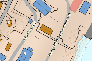
5503 Harstad | 804477bb-2310-4ea9-95e1-58493473a5f5 | 964.95 | N: 7631359.24, Ø: 562205.92 | ![Kartbilde fra WMS-tjeneste av avviket](https://wms.geonorge.no/skwms1/wms.topo?VERSION=1.1.1&SERVICE=WMS&REQUEST=GetMap&LAYERS=topo&STYLES=&FORMAT=image/png&SRS=EPSG:25833&BBOX=562130.0,7631309,562280.0,7631409&WIDTH=300&HEIGHT=200) |
5503 Harstad | 32581201-deb1-4514-b3a5-0327f79752f3 | 688.05 | N: 7607653.58, Ø: 561478.05 | ![Kartbilde fra WMS-tjeneste av avviket](https://wms.geonorge.no/skwms1/wms.topo?VERSION=1.1.1&SERVICE=WMS&REQUEST=GetMap&LAYERS=topo&STYLES=&FORMAT=image/png&SRS=EPSG:25833&BBOX=561403.0,7607603,561553.0,7607703&WIDTH=300&HEIGHT=200) |
5503 Harstad | 0bfdeef5-6d89-4b80-a779-45ac69c4e01b | 593.93 | N: 7632648.21, Ø: 562334.20 | ![Kartbilde fra WMS-tjeneste av avviket](https://wms.geonorge.no/skwms1/wms.topo?VERSION=1.1.1&SERVICE=WMS&REQUEST=GetMap&LAYERS=topo&STYLES=&FORMAT=image/png&SRS=EPSG:25833&BBOX=562259.0,7632598,562409.0,7632698&WIDTH=300&HEIGHT=200) |
5503 Harstad | 4f8b4400-0e22-42dd-9223-98165003389c | 588.36 | N: 7633014.84, Ø: 562258.75 | ![Kartbilde fra WMS-tjeneste av avviket](https://wms.geonorge.no/skwms1/wms.topo?VERSION=1.1.1&SERVICE=WMS&REQUEST=GetMap&LAYERS=topo&STYLES=&FORMAT=image/png&SRS=EPSG:25833&BBOX=562183.0,7632964,562333.0,7633064&WIDTH=300&HEIGHT=200) |
5503 Harstad | 3fe7a049-2064-4f9a-b89b-7f1bc7f32be5 | 569.78 | N: 7630506.49, Ø: 563978.50 | ![Kartbilde fra WMS-tjeneste av avviket](https://wms.geonorge.no/skwms1/wms.topo?VERSION=1.1.1&SERVICE=WMS&REQUEST=GetMap&LAYERS=topo&STYLES=&FORMAT=image/png&SRS=EPSG:25833&BBOX=563903.0,7630456,564053.0,7630556&WIDTH=300&HEIGHT=200) |
5503 Harstad | f2c1360d-5271-4044-b04c-195a7c7e7119 | 513.79 | N: 7632333.67, Ø: 561427.88 | ![Kartbilde fra WMS-tjeneste av avviket](https://wms.geonorge.no/skwms1/wms.topo?VERSION=1.1.1&SERVICE=WMS&REQUEST=GetMap&LAYERS=topo&STYLES=&FORMAT=image/png&SRS=EPSG:25833&BBOX=561352.0,7632283,561502.0,7632383&WIDTH=300&HEIGHT=200) |
5503 Harstad | c7693a24-d7d2-4b3f-a9b6-3a6372f4e9e4 | 503.60 | N: 7631422.98, Ø: 562183.66 | ![Kartbilde fra WMS-tjeneste av avviket](https://wms.geonorge.no/skwms1/wms.topo?VERSION=1.1.1&SERVICE=WMS&REQUEST=GetMap&LAYERS=topo&STYLES=&FORMAT=image/png&SRS=EPSG:25833&BBOX=562108.0,7631372,562258.0,7631472&WIDTH=300&HEIGHT=200) |
5503 Harstad | a0333655-6f35-48fd-8ca7-cd794deb16ec | 471.29 | N: 7630342.60, Ø: 563887.80 | ![Kartbilde fra WMS-tjeneste av avviket](https://wms.geonorge.no/skwms1/wms.topo?VERSION=1.1.1&SERVICE=WMS&REQUEST=GetMap&LAYERS=topo&STYLES=&FORMAT=image/png&SRS=EPSG:25833&BBOX=563812.0,7630292,563962.0,7630392&WIDTH=300&HEIGHT=200) |
5503 Harstad | 9b4d9b24-39bc-4e90-ab41-982b6ac18370 | 256.40 | N: 7621648.98, Ø: 563644.22 | ![Kartbilde fra WMS-tjeneste av avviket](https://wms.geonorge.no/skwms1/wms.topo?VERSION=1.1.1&SERVICE=WMS&REQUEST=GetMap&LAYERS=topo&STYLES=&FORMAT=image/png&SRS=EPSG:25833&BBOX=563569.0,7621598,563719.0,7621698&WIDTH=300&HEIGHT=200) |
5503 Harstad | d595bbde-f723-46fc-8357-78b4b8afca49 | 252.25 | N: 7636429.41, Ø: 563498.11 | ![Kartbilde fra WMS-tjeneste av avviket](https://wms.geonorge.no/skwms1/wms.topo?VERSION=1.1.1&SERVICE=WMS&REQUEST=GetMap&LAYERS=topo&STYLES=&FORMAT=image/png&SRS=EPSG:25833&BBOX=563423.0,7636379,563573.0,7636479&WIDTH=300&HEIGHT=200) |
5503 Harstad | 274b3870-886d-4eca-ae63-8beeccfec935 | 226.48 | N: 7636681.63, Ø: 563564.47 | ![Kartbilde fra WMS-tjeneste av avviket](https://wms.geonorge.no/skwms1/wms.topo?VERSION=1.1.1&SERVICE=WMS&REQUEST=GetMap&LAYERS=topo&STYLES=&FORMAT=image/png&SRS=EPSG:25833&BBOX=563489.0,7636631,563639.0,7636731&WIDTH=300&HEIGHT=200) |
5503 Harstad | 632c19ea-7918-4b1c-9a1e-050b862098cb | 215.24 | N: 7630646.79, Ø: 564214.56 | ![Kartbilde fra WMS-tjeneste av avviket](https://wms.geonorge.no/skwms1/wms.topo?VERSION=1.1.1&SERVICE=WMS&REQUEST=GetMap&LAYERS=topo&STYLES=&FORMAT=image/png&SRS=EPSG:25833&BBOX=564139.0,7630596,564289.0,7630696&WIDTH=300&HEIGHT=200) |
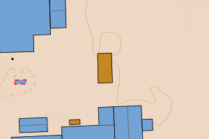
5503 Harstad | 1d86b5ef-7090-4ce8-bad4-bc674e2a3ead | 212.21 | N: 7607557.52, Ø: 561700.71 | ![Kartbilde fra WMS-tjeneste av avviket](https://wms.geonorge.no/skwms1/wms.topo?VERSION=1.1.1&SERVICE=WMS&REQUEST=GetMap&LAYERS=topo&STYLES=&FORMAT=image/png&SRS=EPSG:25833&BBOX=561625.0,7607507,561775.0,7607607&WIDTH=300&HEIGHT=200) |
5503 Harstad | 94fe5923-e70d-48f3-b515-6a26cad60ef5 | 204.54 | N: 7633004.89, Ø: 562327.26 | ![Kartbilde fra WMS-tjeneste av avviket](https://wms.geonorge.no/skwms1/wms.topo?VERSION=1.1.1&SERVICE=WMS&REQUEST=GetMap&LAYERS=topo&STYLES=&FORMAT=image/png&SRS=EPSG:25833&BBOX=562252.0,7632954,562402.0,7633054&WIDTH=300&HEIGHT=200) |
5503 Harstad | 270967f8-ed44-442d-918b-5abb71e8aa05 | 203.40 | N: 7642168.16, Ø: 563709.61 | ![Kartbilde fra WMS-tjeneste av avviket](https://wms.geonorge.no/skwms1/wms.topo?VERSION=1.1.1&SERVICE=WMS&REQUEST=GetMap&LAYERS=topo&STYLES=&FORMAT=image/png&SRS=EPSG:25833&BBOX=563634.0,7642118,563784.0,7642218&WIDTH=300&HEIGHT=200) |
5503 Harstad | 11ecaeb8-d796-4644-9035-c7467e52e827 | 201.83 | N: 7632342.77, Ø: 562243.87 | ![Kartbilde fra WMS-tjeneste av avviket](https://wms.geonorge.no/skwms1/wms.topo?VERSION=1.1.1&SERVICE=WMS&REQUEST=GetMap&LAYERS=topo&STYLES=&FORMAT=image/png&SRS=EPSG:25833&BBOX=562168.0,7632292,562318.0,7632392&WIDTH=300&HEIGHT=200) |