Avvikene skyldes oftest manglende eller unøyaktig registrering av bygningspunkt i matrikkelen. Rettes vanligvis i matrikkelen
Kommune | LokalId | Areal (m2) | Posisjon | WMS-bilde |
4218 Iveland | 15542403-ae58-467a-a792-fa4ebf047058 | 617.45 | N: 6476108.80, Ø: 439965.67 | ![Kartbilde fra WMS-tjeneste av avviket](https://wms.geonorge.no/skwms1/wms.topo?VERSION=1.1.1&SERVICE=WMS&REQUEST=GetMap&LAYERS=topo&STYLES=&FORMAT=image/png&SRS=EPSG:25832&BBOX=439890.0,6476058,440040.0,6476158&WIDTH=300&HEIGHT=200) |
4218 Iveland | 5910a255-0030-40b4-a5a6-19952e2b70c2 | 374.06 | N: 6484663.40, Ø: 437214.14 | ![Kartbilde fra WMS-tjeneste av avviket](https://wms.geonorge.no/skwms1/wms.topo?VERSION=1.1.1&SERVICE=WMS&REQUEST=GetMap&LAYERS=topo&STYLES=&FORMAT=image/png&SRS=EPSG:25832&BBOX=437139.0,6484613,437289.0,6484713&WIDTH=300&HEIGHT=200) |
4218 Iveland | ad59026a-423a-4d69-89da-f06cc5485cf5 | 353.76 | N: 6468964.11, Ø: 435924.50 | ![Kartbilde fra WMS-tjeneste av avviket](https://wms.geonorge.no/skwms1/wms.topo?VERSION=1.1.1&SERVICE=WMS&REQUEST=GetMap&LAYERS=topo&STYLES=&FORMAT=image/png&SRS=EPSG:25832&BBOX=435849.0,6468914,435999.0,6469014&WIDTH=300&HEIGHT=200) |
4218 Iveland | 025f3fc3-68d9-4c2c-a4c9-018151cdcd0e | 323.24 | N: 6467671.65, Ø: 439162.91 | ![Kartbilde fra WMS-tjeneste av avviket](https://wms.geonorge.no/skwms1/wms.topo?VERSION=1.1.1&SERVICE=WMS&REQUEST=GetMap&LAYERS=topo&STYLES=&FORMAT=image/png&SRS=EPSG:25832&BBOX=439087.0,6467621,439237.0,6467721&WIDTH=300&HEIGHT=200) |
4218 Iveland | c0a48751-fde1-4e43-8bf7-dbe1efcbcd39 | 295.07 | N: 6488078.60, Ø: 436817.81 | ![Kartbilde fra WMS-tjeneste av avviket](https://wms.geonorge.no/skwms1/wms.topo?VERSION=1.1.1&SERVICE=WMS&REQUEST=GetMap&LAYERS=topo&STYLES=&FORMAT=image/png&SRS=EPSG:25832&BBOX=436742.0,6488028,436892.0,6488128&WIDTH=300&HEIGHT=200) |
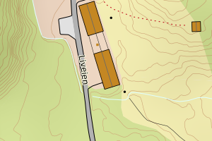
4218 Iveland | 95166cd3-9475-4750-b545-27e6944ce3e5 | 283.86 | N: 6464661.75, Ø: 438476.70 | ![Kartbilde fra WMS-tjeneste av avviket](https://wms.geonorge.no/skwms1/wms.topo?VERSION=1.1.1&SERVICE=WMS&REQUEST=GetMap&LAYERS=topo&STYLES=&FORMAT=image/png&SRS=EPSG:25832&BBOX=438401.0,6464611,438551.0,6464711&WIDTH=300&HEIGHT=200) |
4218 Iveland | 45817f68-2896-4c30-b0f4-5e5d81cd8925 | 259.83 | N: 6472778.38, Ø: 435436.43 | ![Kartbilde fra WMS-tjeneste av avviket](https://wms.geonorge.no/skwms1/wms.topo?VERSION=1.1.1&SERVICE=WMS&REQUEST=GetMap&LAYERS=topo&STYLES=&FORMAT=image/png&SRS=EPSG:25832&BBOX=435361.0,6472728,435511.0,6472828&WIDTH=300&HEIGHT=200) |
4218 Iveland | 59e658ce-6004-48ee-865b-0e76b9cddb0c | 253.42 | N: 6488114.61, Ø: 436806.70 | ![Kartbilde fra WMS-tjeneste av avviket](https://wms.geonorge.no/skwms1/wms.topo?VERSION=1.1.1&SERVICE=WMS&REQUEST=GetMap&LAYERS=topo&STYLES=&FORMAT=image/png&SRS=EPSG:25832&BBOX=436731.0,6488064,436881.0,6488164&WIDTH=300&HEIGHT=200) |
4218 Iveland | 3e7cb3ff-f205-44f1-86c4-b7c7310c29b0 | 244.65 | N: 6476013.56, Ø: 431486.78 | ![Kartbilde fra WMS-tjeneste av avviket](https://wms.geonorge.no/skwms1/wms.topo?VERSION=1.1.1&SERVICE=WMS&REQUEST=GetMap&LAYERS=topo&STYLES=&FORMAT=image/png&SRS=EPSG:25832&BBOX=431411.0,6475963,431561.0,6476063&WIDTH=300&HEIGHT=200) |
4218 Iveland | 9eb0cb1c-1d70-4ca6-a83b-9c0495040011 | 232.84 | N: 6488173.23, Ø: 436817.24 | ![Kartbilde fra WMS-tjeneste av avviket](https://wms.geonorge.no/skwms1/wms.topo?VERSION=1.1.1&SERVICE=WMS&REQUEST=GetMap&LAYERS=topo&STYLES=&FORMAT=image/png&SRS=EPSG:25832&BBOX=436742.0,6488123,436892.0,6488223&WIDTH=300&HEIGHT=200) |
4218 Iveland | 7f69cdf9-a41f-48a4-805b-ef02aaf993d7 | 216.15 | N: 6484149.41, Ø: 432408.99 | ![Kartbilde fra WMS-tjeneste av avviket](https://wms.geonorge.no/skwms1/wms.topo?VERSION=1.1.1&SERVICE=WMS&REQUEST=GetMap&LAYERS=topo&STYLES=&FORMAT=image/png&SRS=EPSG:25832&BBOX=432333.0,6484099,432483.0,6484199&WIDTH=300&HEIGHT=200) |