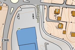
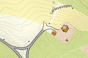
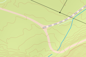
Avviket skyldes enten feilregistreringer i vegnettet (NVDB) eller mangler i FKB-Veg
Kommune | LokalId | Lengde (m) | Vegkategori | Vegnummer | Posisjon | WMS-bilde |
3407 Gjøvik | 2009497_0 | 397.70 | P | 97119 | N: 6756748.06, Ø: 572209.83 | ![Kartbilde fra WMS-tjeneste av avviket](https://wms.geonorge.no/skwms1/wms.topo?VERSION=1.1.1&SERVICE=WMS&REQUEST=GetMap&LAYERS=topo&STYLES=&FORMAT=image/png&SRS=EPSG:25832&BBOX=572134.0,6756698,572284.0,6756798&WIDTH=300&HEIGHT=200) |
3407 Gjøvik | 2009636_0 | 531.95 | P | 97171 | N: 6756798.82, Ø: 571980.33 | ![Kartbilde fra WMS-tjeneste av avviket](https://wms.geonorge.no/skwms1/wms.topo?VERSION=1.1.1&SERVICE=WMS&REQUEST=GetMap&LAYERS=topo&STYLES=&FORMAT=image/png&SRS=EPSG:25832&BBOX=571905.0,6756748,572055.0,6756848&WIDTH=300&HEIGHT=200) |
3407 Gjøvik | 2021933_1 | 1560.32 | P | 96558 | N: 6742831.83, Ø: 578106.27 | ![Kartbilde fra WMS-tjeneste av avviket](https://wms.geonorge.no/skwms1/wms.topo?VERSION=1.1.1&SERVICE=WMS&REQUEST=GetMap&LAYERS=topo&STYLES=&FORMAT=image/png&SRS=EPSG:25832&BBOX=578031.0,6742781,578181.0,6742881&WIDTH=300&HEIGHT=200) |
3407 Gjøvik | 1057011_1 | 409.70 | S | 924 | N: 6748698.09, Ø: 578513.13 | ![Kartbilde fra WMS-tjeneste av avviket](https://wms.geonorge.no/skwms1/wms.topo?VERSION=1.1.1&SERVICE=WMS&REQUEST=GetMap&LAYERS=topo&STYLES=&FORMAT=image/png&SRS=EPSG:25832&BBOX=578438.0,6748648,578588.0,6748748&WIDTH=300&HEIGHT=200) |
3407 Gjøvik | 2012657_0 | 556.73 | P | 97106 | N: 6748105.01, Ø: 579225.85 | ![Kartbilde fra WMS-tjeneste av avviket](https://wms.geonorge.no/skwms1/wms.topo?VERSION=1.1.1&SERVICE=WMS&REQUEST=GetMap&LAYERS=topo&STYLES=&FORMAT=image/png&SRS=EPSG:25832&BBOX=579150.0,6748055,579300.0,6748155&WIDTH=300&HEIGHT=200) |
3407 Gjøvik | 1057011_2 | 312.89 | S | 924 | N: 6748736.72, Ø: 578883.70 | ![Kartbilde fra WMS-tjeneste av avviket](https://wms.geonorge.no/skwms1/wms.topo?VERSION=1.1.1&SERVICE=WMS&REQUEST=GetMap&LAYERS=topo&STYLES=&FORMAT=image/png&SRS=EPSG:25832&BBOX=578808.0,6748686,578958.0,6748786&WIDTH=300&HEIGHT=200) |
3407 Gjøvik | 1008762_0 | 140.32 | P | 98064 | N: 6761597.76, Ø: 584442.88 | ![Kartbilde fra WMS-tjeneste av avviket](https://wms.geonorge.no/skwms1/wms.topo?VERSION=1.1.1&SERVICE=WMS&REQUEST=GetMap&LAYERS=topo&STYLES=&FORMAT=image/png&SRS=EPSG:25832&BBOX=584367.0,6761547,584517.0,6761647&WIDTH=300&HEIGHT=200) |
3407 Gjøvik | 2017516_2 | 124.29 | P | 96715 | N: 6740737.63, Ø: 588487.17 | ![Kartbilde fra WMS-tjeneste av avviket](https://wms.geonorge.no/skwms1/wms.topo?VERSION=1.1.1&SERVICE=WMS&REQUEST=GetMap&LAYERS=topo&STYLES=&FORMAT=image/png&SRS=EPSG:25832&BBOX=588412.0,6740687,588562.0,6740787&WIDTH=300&HEIGHT=200) |
3407 Gjøvik | 1010394_0 | 107.85 | P | 99704 | N: 6742193.31, Ø: 579960.43 | ![Kartbilde fra WMS-tjeneste av avviket](https://wms.geonorge.no/skwms1/wms.topo?VERSION=1.1.1&SERVICE=WMS&REQUEST=GetMap&LAYERS=topo&STYLES=&FORMAT=image/png&SRS=EPSG:25832&BBOX=579885.0,6742143,580035.0,6742243&WIDTH=300&HEIGHT=200) |
3407 Gjøvik | 1056809_1 | 1996.90 | S | 50 | N: 6760777.93, Ø: 573580.35 | ![Kartbilde fra WMS-tjeneste av avviket](https://wms.geonorge.no/skwms1/wms.topo?VERSION=1.1.1&SERVICE=WMS&REQUEST=GetMap&LAYERS=topo&STYLES=&FORMAT=image/png&SRS=EPSG:25832&BBOX=573505.0,6760727,573655.0,6760827&WIDTH=300&HEIGHT=200) |
3407 Gjøvik | 1056920_0 | 720.90 | S | 155 | N: 6760777.93, Ø: 573580.35 | ![Kartbilde fra WMS-tjeneste av avviket](https://wms.geonorge.no/skwms1/wms.topo?VERSION=1.1.1&SERVICE=WMS&REQUEST=GetMap&LAYERS=topo&STYLES=&FORMAT=image/png&SRS=EPSG:25832&BBOX=573505.0,6760727,573655.0,6760827&WIDTH=300&HEIGHT=200) |
3407 Gjøvik | 1056776_0 | 1271.59 | S | 24 | N: 6747400.75, Ø: 573540.84 | ![Kartbilde fra WMS-tjeneste av avviket](https://wms.geonorge.no/skwms1/wms.topo?VERSION=1.1.1&SERVICE=WMS&REQUEST=GetMap&LAYERS=topo&STYLES=&FORMAT=image/png&SRS=EPSG:25832&BBOX=573465.0,6747350,573615.0,6747450&WIDTH=300&HEIGHT=200) |
3407 Gjøvik | 2009534_0 | 177.72 | P | 97157 | N: 6756861.30, Ø: 573028.60 | ![Kartbilde fra WMS-tjeneste av avviket](https://wms.geonorge.no/skwms1/wms.topo?VERSION=1.1.1&SERVICE=WMS&REQUEST=GetMap&LAYERS=topo&STYLES=&FORMAT=image/png&SRS=EPSG:25832&BBOX=572953.0,6756811,573103.0,6756911&WIDTH=300&HEIGHT=200) |
3407 Gjøvik | 2009507_0 | 298.08 | P | 97127 | N: 6756748.10, Ø: 572767.69 | ![Kartbilde fra WMS-tjeneste av avviket](https://wms.geonorge.no/skwms1/wms.topo?VERSION=1.1.1&SERVICE=WMS&REQUEST=GetMap&LAYERS=topo&STYLES=&FORMAT=image/png&SRS=EPSG:25832&BBOX=572692.0,6756698,572842.0,6756798&WIDTH=300&HEIGHT=200) |
3407 Gjøvik | 1008227_0 | 208.27 | P | 5378 | N: 6739158.65, Ø: 592855.48 | ![Kartbilde fra WMS-tjeneste av avviket](https://wms.geonorge.no/skwms1/wms.topo?VERSION=1.1.1&SERVICE=WMS&REQUEST=GetMap&LAYERS=topo&STYLES=&FORMAT=image/png&SRS=EPSG:25832&BBOX=592780.0,6739108,592930.0,6739208&WIDTH=300&HEIGHT=200) |
3407 Gjøvik | 3495712_0 | 116.03 | P | 99969 | N: 6738821.84, Ø: 593157.47 | ![Kartbilde fra WMS-tjeneste av avviket](https://wms.geonorge.no/skwms1/wms.topo?VERSION=1.1.1&SERVICE=WMS&REQUEST=GetMap&LAYERS=topo&STYLES=&FORMAT=image/png&SRS=EPSG:25832&BBOX=593082.0,6738771,593232.0,6738871&WIDTH=300&HEIGHT=200) |
3407 Gjøvik | 3495706_0 | 114.34 | P | 99960 | N: 6738728.75, Ø: 591027.08 | ![Kartbilde fra WMS-tjeneste av avviket](https://wms.geonorge.no/skwms1/wms.topo?VERSION=1.1.1&SERVICE=WMS&REQUEST=GetMap&LAYERS=topo&STYLES=&FORMAT=image/png&SRS=EPSG:25832&BBOX=590952.0,6738678,591102.0,6738778&WIDTH=300&HEIGHT=200) |
3407 Gjøvik | 3588683_0 | 236.85 | P | 96240 | N: 6739488.55, Ø: 589196.30 | ![Kartbilde fra WMS-tjeneste av avviket](https://wms.geonorge.no/skwms1/wms.topo?VERSION=1.1.1&SERVICE=WMS&REQUEST=GetMap&LAYERS=topo&STYLES=&FORMAT=image/png&SRS=EPSG:25832&BBOX=589121.0,6739438,589271.0,6739538&WIDTH=300&HEIGHT=200) |
3407 Gjøvik | 3495583_0 | 184.81 | P | 99981 | N: 6739436.43, Ø: 589191.97 | ![Kartbilde fra WMS-tjeneste av avviket](https://wms.geonorge.no/skwms1/wms.topo?VERSION=1.1.1&SERVICE=WMS&REQUEST=GetMap&LAYERS=topo&STYLES=&FORMAT=image/png&SRS=EPSG:25832&BBOX=589116.0,6739386,589266.0,6739486&WIDTH=300&HEIGHT=200) |
3407 Gjøvik | 2810583_1 | 105.41 | P | 5703 | N: 6741601.95, Ø: 590077.70 | ![Kartbilde fra WMS-tjeneste av avviket](https://wms.geonorge.no/skwms1/wms.topo?VERSION=1.1.1&SERVICE=WMS&REQUEST=GetMap&LAYERS=topo&STYLES=&FORMAT=image/png&SRS=EPSG:25832&BBOX=590002.0,6741551,590152.0,6741651&WIDTH=300&HEIGHT=200) |
3407 Gjøvik | 1010274_0 | 108.10 | P | 99584 | N: 6741020.48, Ø: 590222.71 | ![Kartbilde fra WMS-tjeneste av avviket](https://wms.geonorge.no/skwms1/wms.topo?VERSION=1.1.1&SERVICE=WMS&REQUEST=GetMap&LAYERS=topo&STYLES=&FORMAT=image/png&SRS=EPSG:25832&BBOX=590147.0,6740970,590297.0,6741070&WIDTH=300&HEIGHT=200) |
3407 Gjøvik | 3939918_0 | 139.50 | P | 96228 | N: 6755738.89, Ø: 587977.86 | ![Kartbilde fra WMS-tjeneste av avviket](https://wms.geonorge.no/skwms1/wms.topo?VERSION=1.1.1&SERVICE=WMS&REQUEST=GetMap&LAYERS=topo&STYLES=&FORMAT=image/png&SRS=EPSG:25832&BBOX=587902.0,6755688,588052.0,6755788&WIDTH=300&HEIGHT=200) |
3407 Gjøvik | 3131906_1 | 123.43 | P | 95200 | N: 6739003.20, Ø: 592630.59 | ![Kartbilde fra WMS-tjeneste av avviket](https://wms.geonorge.no/skwms1/wms.topo?VERSION=1.1.1&SERVICE=WMS&REQUEST=GetMap&LAYERS=topo&STYLES=&FORMAT=image/png&SRS=EPSG:25832&BBOX=592555.0,6738953,592705.0,6739053&WIDTH=300&HEIGHT=200) |
3407 Gjøvik | 3135952_0 | 619.59 | P | 99770 | N: 6755419.29, Ø: 566772.14 | ![Kartbilde fra WMS-tjeneste av avviket](https://wms.geonorge.no/skwms1/wms.topo?VERSION=1.1.1&SERVICE=WMS&REQUEST=GetMap&LAYERS=topo&STYLES=&FORMAT=image/png&SRS=EPSG:25832&BBOX=566697.0,6755369,566847.0,6755469&WIDTH=300&HEIGHT=200) |
3407 Gjøvik | 1056810_2 | 800.63 | S | 51 | N: 6763982.41, Ø: 569591.74 | ![Kartbilde fra WMS-tjeneste av avviket](https://wms.geonorge.no/skwms1/wms.topo?VERSION=1.1.1&SERVICE=WMS&REQUEST=GetMap&LAYERS=topo&STYLES=&FORMAT=image/png&SRS=EPSG:25832&BBOX=569516.0,6763932,569666.0,6764032&WIDTH=300&HEIGHT=200) |
3407 Gjøvik | 2007971_0 | 147.79 | P | 97335 | N: 6760626.15, Ø: 580533.56 | ![Kartbilde fra WMS-tjeneste av avviket](https://wms.geonorge.no/skwms1/wms.topo?VERSION=1.1.1&SERVICE=WMS&REQUEST=GetMap&LAYERS=topo&STYLES=&FORMAT=image/png&SRS=EPSG:25832&BBOX=580458.0,6760576,580608.0,6760676&WIDTH=300&HEIGHT=200) |