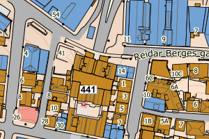
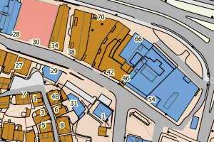
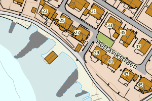
Avvikene skyldes enten feilregistrering i matrikkel eller manglende bygningsdelelinje i FKB-Bygning. Rettes i matrikkelen eller FKB-Bygning
Kommune | LokalId | Bygningsnummer (punkt) | Bygningsnummer (flate) | Posisjon | WMS-bilde |
1103 Stavanger | f14c890e-fc3d-4788-a928-397b5366c67f | 4735137 | 4814312 | N: 6541320.78, Ø: 312774.74 | ![Kartbilde fra WMS-tjeneste av avviket](https://wms.geonorge.no/skwms1/wms.topo?VERSION=1.1.1&SERVICE=WMS&REQUEST=GetMap&LAYERS=topo&STYLES=&FORMAT=image/png&SRS=EPSG:25832&BBOX=312699.0,6541270,312849.0,6541370&WIDTH=300&HEIGHT=200) |
1103 Stavanger | ae881890-9944-4e01-b41b-6619da9f3a0f | 301436156 | 300110611 | N: 6535374.90, Ø: 312204.61 | ![Kartbilde fra WMS-tjeneste av avviket](https://wms.geonorge.no/skwms1/wms.topo?VERSION=1.1.1&SERVICE=WMS&REQUEST=GetMap&LAYERS=topo&STYLES=&FORMAT=image/png&SRS=EPSG:25832&BBOX=312129.0,6535324,312279.0,6535424&WIDTH=300&HEIGHT=200) |
1103 Stavanger | ae881890-9944-4e01-b41b-6619da9f3a0f | 301436156 | 300110600 | N: 6535374.90, Ø: 312204.61 | ![Kartbilde fra WMS-tjeneste av avviket](https://wms.geonorge.no/skwms1/wms.topo?VERSION=1.1.1&SERVICE=WMS&REQUEST=GetMap&LAYERS=topo&STYLES=&FORMAT=image/png&SRS=EPSG:25832&BBOX=312129.0,6535324,312279.0,6535424&WIDTH=300&HEIGHT=200) |
1103 Stavanger | ae881890-9944-4e01-b41b-6619da9f3a0f | 301436156 | 301436157 | N: 6535374.90, Ø: 312204.61 | ![Kartbilde fra WMS-tjeneste av avviket](https://wms.geonorge.no/skwms1/wms.topo?VERSION=1.1.1&SERVICE=WMS&REQUEST=GetMap&LAYERS=topo&STYLES=&FORMAT=image/png&SRS=EPSG:25832&BBOX=312129.0,6535324,312279.0,6535424&WIDTH=300&HEIGHT=200) |
1103 Stavanger | cd3c5e8a-ec91-4f03-8fb6-b727c66c93c8 | 301436196 | 300802022 | N: 6535375.28, Ø: 312300.46 | ![Kartbilde fra WMS-tjeneste av avviket](https://wms.geonorge.no/skwms1/wms.topo?VERSION=1.1.1&SERVICE=WMS&REQUEST=GetMap&LAYERS=topo&STYLES=&FORMAT=image/png&SRS=EPSG:25832&BBOX=312225.0,6535325,312375.0,6535425&WIDTH=300&HEIGHT=200) |
1103 Stavanger | cd3c5e8a-ec91-4f03-8fb6-b727c66c93c8 | 301436196 | 300802033 | N: 6535375.28, Ø: 312300.46 | ![Kartbilde fra WMS-tjeneste av avviket](https://wms.geonorge.no/skwms1/wms.topo?VERSION=1.1.1&SERVICE=WMS&REQUEST=GetMap&LAYERS=topo&STYLES=&FORMAT=image/png&SRS=EPSG:25832&BBOX=312225.0,6535325,312375.0,6535425&WIDTH=300&HEIGHT=200) |
1103 Stavanger | cd3c5e8a-ec91-4f03-8fb6-b727c66c93c8 | 301436196 | 301436195 | N: 6535375.28, Ø: 312300.46 | ![Kartbilde fra WMS-tjeneste av avviket](https://wms.geonorge.no/skwms1/wms.topo?VERSION=1.1.1&SERVICE=WMS&REQUEST=GetMap&LAYERS=topo&STYLES=&FORMAT=image/png&SRS=EPSG:25832&BBOX=312225.0,6535325,312375.0,6535425&WIDTH=300&HEIGHT=200) |
1103 Stavanger | 01708ffd-b39d-4f14-9f2c-27de3e880bb6 | 301436197 | 300802022 | N: 6535369.95, Ø: 312302.03 | ![Kartbilde fra WMS-tjeneste av avviket](https://wms.geonorge.no/skwms1/wms.topo?VERSION=1.1.1&SERVICE=WMS&REQUEST=GetMap&LAYERS=topo&STYLES=&FORMAT=image/png&SRS=EPSG:25832&BBOX=312227.0,6535319,312377.0,6535419&WIDTH=300&HEIGHT=200) |
1103 Stavanger | 01708ffd-b39d-4f14-9f2c-27de3e880bb6 | 301436197 | 300802033 | N: 6535369.95, Ø: 312302.03 | ![Kartbilde fra WMS-tjeneste av avviket](https://wms.geonorge.no/skwms1/wms.topo?VERSION=1.1.1&SERVICE=WMS&REQUEST=GetMap&LAYERS=topo&STYLES=&FORMAT=image/png&SRS=EPSG:25832&BBOX=312227.0,6535319,312377.0,6535419&WIDTH=300&HEIGHT=200) |
1103 Stavanger | 01708ffd-b39d-4f14-9f2c-27de3e880bb6 | 301436197 | 301436195 | N: 6535369.95, Ø: 312302.03 | ![Kartbilde fra WMS-tjeneste av avviket](https://wms.geonorge.no/skwms1/wms.topo?VERSION=1.1.1&SERVICE=WMS&REQUEST=GetMap&LAYERS=topo&STYLES=&FORMAT=image/png&SRS=EPSG:25832&BBOX=312227.0,6535319,312377.0,6535419&WIDTH=300&HEIGHT=200) |
1103 Stavanger | 5f2f4726-757f-440e-9a02-1573fe8054c6 | 4634748 | 4642449 | N: 6540470.00, Ø: 305291.00 | ![Kartbilde fra WMS-tjeneste av avviket](https://wms.geonorge.no/skwms1/wms.topo?VERSION=1.1.1&SERVICE=WMS&REQUEST=GetMap&LAYERS=topo&STYLES=&FORMAT=image/png&SRS=EPSG:25832&BBOX=305215.0,6540420,305365.0,6540520&WIDTH=300&HEIGHT=200) |
1103 Stavanger | 7d57c1b6-9eff-44cf-8386-b563bec6a472 | 300422271 | 300573145 | N: 6535522.90, Ø: 311812.60 | ![Kartbilde fra WMS-tjeneste av avviket](https://wms.geonorge.no/skwms1/wms.topo?VERSION=1.1.1&SERVICE=WMS&REQUEST=GetMap&LAYERS=topo&STYLES=&FORMAT=image/png&SRS=EPSG:25832&BBOX=311737.0,6535472,311887.0,6535572&WIDTH=300&HEIGHT=200) |
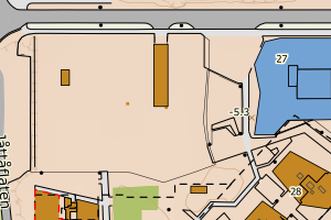
1103 Stavanger | 8350fc18-4094-4ea8-8bed-2d9d24fcbb50 | 4623444 | 4720334 | N: 6541832.00, Ø: 311534.00 | ![Kartbilde fra WMS-tjeneste av avviket](https://wms.geonorge.no/skwms1/wms.topo?VERSION=1.1.1&SERVICE=WMS&REQUEST=GetMap&LAYERS=topo&STYLES=&FORMAT=image/png&SRS=EPSG:25832&BBOX=311458.0,6541781,311608.0,6541881&WIDTH=300&HEIGHT=200) |
1103 Stavanger | 903cab4b-542a-4092-b49b-9247ddd6049a | 300548042 | 300548062 | N: 6541383.60, Ø: 312703.60 | ![Kartbilde fra WMS-tjeneste av avviket](https://wms.geonorge.no/skwms1/wms.topo?VERSION=1.1.1&SERVICE=WMS&REQUEST=GetMap&LAYERS=topo&STYLES=&FORMAT=image/png&SRS=EPSG:25832&BBOX=312628.0,6541333,312778.0,6541433&WIDTH=300&HEIGHT=200) |